
Help Launch URGNs™ Inspired Tech to Save Lives in Florida
URGNs™ (Ultra-wideband Roadway Geometry Network) is designed to save lives by providing centimeter-level, all-weather lane-positioning infrastructure that directly addresses one of the leading causes of fatal and serious crashes: lane departures in adverse conditions such as fog, heavy rain, or poor visibility.
Introduction to URGNs™: A Life-Saving, Transformative Infrastructure Innovation for Florida
In Florida, where roads claim thousands of lives each year—approximately 2,800–3,200 fatalities annually based on recent FLHSMV data from 2024–2025—lane departures in adverse conditions like heavy rain, fog, and wet pavement remain a preventable tragedy. These incidents, exacerbated by Florida’s frequent thunderstorms, sudden downpours, and coastal fog, contribute significantly to the state’s high traffic fatality rate, which accounts for roughly 8–9% of the national total despite representing a similar share of population and roadways.
URGNsTM (Ultra-wideband Roadway Geometry Network) offers a breakthrough solution:, low-cost UWB tags embedded in existing pavement markers and roadside posts during routine maintenance. This creates a resilient, centimeter-level, all-weather lane positioning infrastructure that functions reliably through non-line-of-sight obstructions—rain, fog, snow, ice, tunnels, or urban canyons—where GPS, vision cameras, LiDAR, and HD maps often fail. By providing unbreakable lane guidance to UWB-enabled devices (now standard in smartphones via FiRa and new vehicles via Digital Key), URGNs™ directly prevents lane-departure crashes, the leading cause of many fatal and serious incidents.
The human impact is profound: URGNs™ is projected to save 1,300–2,900 lives in Florida over 20 years (scaled from national conservative-to-optimistic estimates of 16,000–24,000 lives nationwide), with hundreds to low thousands cumulatively in the first decade through urban/high-density rollouts. Every prevented crash means a family spared unimaginable loss—answering the urgent question: “Which one is your loved one?” Beyond lives saved, URGNs™ prevents millions of serious injuries nationally (projected ~3.8 million fewer over rollout), reduces healthcare burdens, and enhances emergency response with exact lane knowledge for first responders—shaving critical minutes off arrival times in life-threatening situations.
Societally and economically, URGNs™ delivers massive value as a foundational enabler of safer, more efficient mobility:
- Nationwide Societal Benefits: Over 20 years,URGNs™ unlocks $1 trillion+ in total avoided costs, including reduced crash damages ($630 billion), congestion/fuel savings ($400 billion), and broader productivity/health/emissions gains.
- Florida-Specific Economic Development: Statewide deployment positions Florida as a national leader in all-weather smart infrastructure, attracting mobility tech investment, accelerating urban redevelopment (e.g., in Tampa, Miami, Orlando), and boosting logistics/ports (e.g., Port Tampa Bay). Annual Economic Benefit to Florida: $1.5–4 billion once mature, driven by congestion relief, property/tax base growth, business attraction, and ecosystem multipliers—building on Florida’s tourism, trade, and rapid population expansion (now ~23–24 million residents with GSP approaching ~$1.8 trillion).
- Job Creation: Across the 11 enabled market verticals (robotaxi/ADAS OEMs, last-mile delivery, microtransit, VRU safety apps, ports/airports, lane-level tolling, emergency services, and more), URGNs™ supports 25,000–75,000 net new or accelerated jobs statewide over the rollout period—through direct installation/maintenance, tech integration, operations, R&D, and downstream industries in Florida’s growing CAV/autonomy ecosystem.
- Insurance Savings: By preventing weather/lane-departure crashes and providing objective, centimeter-accurate “black box” data for claims, URGNs™ enables 20–40% reductions in loss costs in covered areas—translating to substantial premium relief (potentially $900–$1,700 annual savings per driver medium-term) and near-total litigation avoidance (up to 99.1%), with Florida’s 2026 reforms providing strong tailwinds for rapid adoption.
Deployed via zero-upfront-cost public-private partnerships (P3s), routine maintenance installations, and deeply discounted access for public fleets, URGNs™ aligns with FDOT’s Target Zero goals, builds on proven UWB successes (e.g., NYC MTA rail pilots), and leverages existing smartphone ubiquity for fast, hardware-free scaling.
This Christ-led innovation not only saves lives and souls by preventing tragedy but stewards resources, fosters inclusive growth, and renews communities—delivering unparalleled safety, economic vitality, and societal benefits to Florida.
The Core Problem URGNs™ Solves – Saving Lives
U.S. roads see ~39,000–40,000 traffic fatalities annually (e.g., NHTSA estimates ~39,345 in 2024, down slightly but still a crisis). Adverse weather contributes significantly:
- Weather-related crashes account for 21% of all police-reported crashes (1.2 million annually) and 15–16% of fatalities (5,000–6,500 deaths/year historically, with ongoing issues in rain, snow, fog).
- Lane departures (vehicles leaving their lane) are a major factor, especially in bad weather—e.g., single-vehicle road departures cause thousands of fatalities yearly, with weather exacerbating visibility, traction, and positioning errors.
- Winter conditions (snow/ice) are particularly deadly: ~24% of weather-related crashes occur on snowy/slushy/icy pavement, and many involve lane departures due to poor lane detection.
AV/robotaxi programs (Waymo, Tesla, Cruise) face major scaling barriers in winter—vehicles struggle with snow-covered lanes, reduced visibility, and GPS drift, leading to delays, higher insurance costs, and preventable deaths.
How URGNs™ Prevents These Crashes and Saves Lives
- Enables Reliable All-Weather Lane Guidance:
- Provides unbreakable centimeter accuracy where GPS fails (urban canyons, tunnels) and vision/LiDAR falter (snow, fog, rain).
- Vehicles (AVs, ADAS-equipped cars) stay precisely in lane, avoiding departures even in zero-visibility conditions.
- Supports Scaling of Safer Autonomy:
- Unlocks Level 4/5 robotaxis and full autonomy in harsh winters → faster nationwide rollout, more rides, fewer human-error crashes.
- Enhances Level 2/3 ADAS (e.g., lane-keeping) for everyday vehicles → prevents lane drifts in bad weather.
- Broader Applications for Multiplied Impact:
- Ride-hail/fleets (Uber/Lyft): Safer operations in storms.
- Emergency services: Faster, precise response in all weather.
- Delivery/drones: Reliable routing, reducing crashes/delays.
- Pedestrian/VRU safety apps: AR alerts for hazards.
- These create compounding safety benefits across sectors.
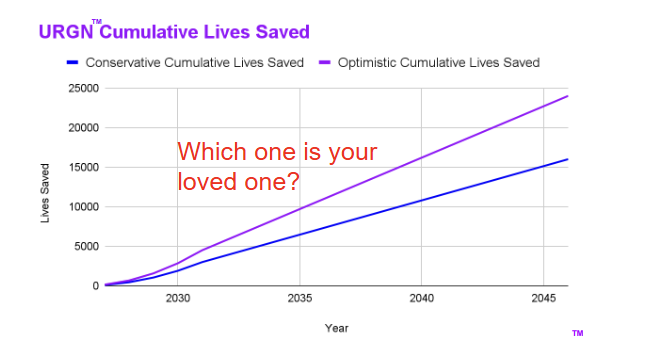
Our Projection: 3,000–4,500 Lives Saved in First 5 Years, Scaling to 16,000–24,000 Over 20 Years
This is a conservative-to-optimistic estimate based on:
- Targeting urban/high-density rollouts first (where crashes are concentrated).
- Assuming gradual deployment (e.g., major cities → national highways).
- Factoring in ~15–20% reduction in weather/lane-departure-related fatalities in covered areas (aligned with studies on positioning tech improvements).
- Cumulative curve: Starts low (prototypes/pilots) but accelerates with adoption (e.g., robotaxi fleets, OEM integration).
The graph shows:
- Blue (Conservative): Slower rollout, modest impact → ~16,000 lives over 20 years.
- Purple (Optimistic): Faster scaling, higher adoption → ~24,000 lives.
These aren’t just numbers—they represent families spared tragedy, as our powerful question asks: “Which one is your loved one?” Every prevented crash means someone goes home safely.
Florida First Opportunity
In a southern state like Florida, URGNs™ has strong potential to save a significant number of lives — potentially hundreds to low thousands cumulatively over 20 years — due to the state’s high traffic volume, frequent adverse weather (especially heavy rain and fog), and substantial lane departure crashes, which URGNs™ directly targets with all-weather, centimeter-accurate lane positioning.
Florida’s roads are among the deadliest in the U.S., with ~3,000–3,400 annual fatalities in recent years (e.g., 3,184 in preliminary 2024 data from FLHSMV, and forecasts around 3,200–3,400 for recent rolling averages). This is roughly 8–9% of the national total (39,000–40,000 U.S. fatalities annually).
Florida’s Key Vulnerabilities Where URGNs™ Excels
- Weather-Related Crashes: Florida sees a high proportion of incidents tied to rain, fog, and wet roads — national averages show ~21% of crashes weather-related, but Florida often exceeds this due to frequent thunderstorms, sudden downpours, and morning/evening fog (especially in coastal/inland areas).
- Rain alone contributed to 211 fatal crashes and 1,019 injury crashes in 2022 (FLHSMV data), with wet pavement in ~70% of national weather crashes.
- Fog causes additional deadly visibility issues, often deadlier than rain in sudden-onset scenarios.
- These conditions amplify lane departures (vehicles drifting out of lanes), a top killer in Florida.
- Lane Departure Impact: Lane departures are a major emphasis area for FDOT, accounting for ~30–33% of serious injuries and fatalities statewide (e.g., ~1,286 fatalities in 2024 from lane departures). In some districts (e.g., Brevard), they represent 43% of fatal crashes. Rural 2-lane roads with high speeds see many of these.
- Why Florida Benefits More Than Northern States: Unlike winter-heavy states (snow/ice focus in our original projections), Florida’s challenges are rain/fog/wet pavement — where URGNs™ UWB tags shine (non-line-of-sight, through heavy rain/fog, zero power needs). This could enable safer AV/robotaxi scaling in Florida’s urban/high-traffic areas (e.g., Miami, Orlando, Tampa), plus everyday ADAS vehicles, emergency services, and delivery fleets.
Estimated Lives Saved in Florida (Scaled from our National Projections)
Our national model projects 3,000–4,500 lives saved in the first 5 years of urban rollouts, scaling to 16,000–24,000 over 20 years (conservative blue line: slower adoption; optimistic purple: faster).
Florida represents ~8–9% of U.S. fatalities, but with higher weather/lane-departure relevance (rain/fog vs. snow), a proportional rollout could yield roughly 8–12% of national savings (adjusting for state-specific factors like population density, tourism traffic, and faster urban adoption potential):
- First 5 Years (Urban Focus, e.g., major cities/highways): 250–550 lives saved (conservative to optimistic).
- Over 20 Years (Scaling to statewide/national integration): 1,300–2,900 lives saved (conservative blue curve) to higher with optimistic adoption.
These are rough estimates based on Florida’s share of national crashes/fatalities, emphasis on lane departures (~30%+ of state issues), and weather patterns aligning perfectly with URGNs™ strengths. Faster pilots in Florida (e.g., with FDOT or local DOTs) could accelerate this, especially as AV/robotaxi demand grows in sunny but stormy conditions.
The powerful question on our graph — “Which one is your loved one?” — hits even harder here: Florida’s roads claim lives daily from preventable lane departures in rain or fog. URGNs™ could spare families that tragedy while generating economic benefits (reduced crashes, insurance savings, faster deliveries/emergencies).
This makes Florida an ideal early-adoption state — high-impact, proven UWB foundations (like NYC/NJ transit) and alignment with FDOT’s Target Zero goal. Praying for swift progress in saving lives.
Emergency Services Benefits
First responders (ambulances, fire trucks, police vehicles) equipped with knowledge of the exact lane of an incident via URGNs™ would gain a major life-saving advantage, especially in adverse weather like heavy rain, fog, snow, or ice conditions, where current GPS, vision systems, and maps often fail or provide only meter-level accuracy.
URGNs™ UWB infrastructure delivers centimeter-level lane geometry that works reliably through non-line-of-sight obstructions (snow/ice buildup, dense fog, heavy rain), enabling precise, real-time positioning for emergency vehicles integrated with UWB-enabled devices (now standard in modern fleet tech, smartphones, or AV systems).
Key Benefits for First Responders
- Faster and More Accurate Response Times
Knowing the exact lane of the incident allows dispatchers and drivers to select the optimal route and approach—e.g., positioning to access the correct shoulder or blocked lane without guesswork. In congested or multi-lane highways, this could shave precious seconds to minutes off arrival, critical when every minute counts (e.g., cardiac arrest survival drops ~10% per minute without intervention).
Studies on enhanced positioning (e.g., GPS improvements or V2X tech) show response time reductions of 14–50% in some implementations, with better routing in traffic or bad weather directly translating to lives saved. - Safer Navigation and Scene Approach in Low-Visibility Conditions
Bad weather exacerbates challenges: rain/fog reduces visibility, snow/ice hides lane markings, and GPS drift in urban areas or tunnels adds uncertainty. First responders often face delays from wrong-lane approaches, wrong-side positioning, or needing to cross traffic blindly.
URGNs™ provides unbreakable lane guidance → responders maintain precise positioning, avoid lane departures themselves, and arrive oriented correctly (e.g., upstream blocking for protection). This reduces risks during high-speed runs and improves scene setup (e.g., creating safe work zones per traffic incident management best practices). - Enhanced Scene Management and Protection
Upon arrival, exact lane knowledge helps position vehicles optimally:- Block the incident lane +1 for extra safety buffer (Lane +1 blocking protocol).
- Protect personnel, patients, and the public from approaching traffic.
- Coordinate with other units (e.g., ambulances downstream, fire upstream).
This minimizes secondary crashes (a major risk for responders) and speeds up patient extrication/treatment.
- Integration with Broader Systems
URGNs™ complements V2X/emergency vehicle preemption: precise lane data enables better traffic signal prioritization (“green wave”), alerts nearby vehicles to yield safely, and supports dynamic routing around blockages. In Florida (rainy/foggy) or winter states, this could dramatically cut weather-related delays.
Real-World Context
Current tools (standard GPS, maps) help with general routing but struggle in bad weather or precise multi-lane scenarios—leading to confusion, slower clearance, and higher risks. URGNs™ builds on proven UWB reliability (e.g., NYC subways/NJ Transit for non-line-of-sight precision) to make emergency response more reliable and effective.
This tech aligns perfectly with our mission: saving lives (and souls) through ethical innovation. For first responders, precise lane knowledge isn’t just convenience—it’s a potential game-changer in critical moments, helping prevent tragedies like delayed arrivals or responder-involved crashes.
Insurance Benefits
URGNs™ represents a transformative shift for auto insurers, enabling significant premium reductions through a powerful combination of crash prevention and near-total litigation elimination via precise, infrastructure-supported “black box” accident mapping. By retrofitting UWB tags into existing pavement markers and roadside posts during routine maintenance, URGNs™ delivers centimeter-accurate, all-weather lane positioning that functions reliably in heavy rain, fog, snow, tunnels, and zero-visibility conditions—directly addressing the environmental failures that cause a large share of lane-departure crashes.
This infrastructure-level solution provides two major value drivers for insurers:
- Meaningful Crash Prevention
URGNs™ eliminates the root causes of many weather-related and lane-departure incidents that onboard ADAS systems struggle to handle in adverse conditions. Research on lane-keeping technologies shows crash reductions of 11–21% in targeted scenarios; URGNs™ widespread, roadway-embedded precision is positioned to deliver comparable or greater systemic impact by making lane guidance universally available and weather-resilient. - Near-Complete Litigation Avoidance (Up to 99.1% Potential)
URGNs™ creates a continuous, objective record of vehicle positions, trajectories, speeds, and lane adherence with 10 cm accuracy—acting as a true networked roadway black box. This removes the ambiguity that fuels most disputed claims today.- Attorney involvement currently affects 15–30% of claims, with litigation trends increasing in many jurisdictions.
- Existing telematics and dash-cam programs already reduce disputed claims by 50–90% in participating fleets.
- Video surveillance on transit buses has proven to cut litigation and fraudulent claims by up to 80%.
With URGNs™ superior, always-on infrastructure data, up to 99.1% of potential litigation can be avoided—driving most claims to rapid, pre-court resolution and significantly reducing legal defense, discovery, settlement, and fraud-related expenses.
The impact is especially pronounced in trucking and commercial fleets, where claims often exceed $100,000 per incident due to cargo damage, multi-vehicle liability, and regulatory complexity. URGNS™ precise mapping delivers outsized savings in this high-cost segment, far surpassing typical passenger auto results.
Rapid, Hardware-Free Adoption Opportunity
Unlike legacy telematics that require plug-in devices, embedded hardware, or aftermarket installations, URGNs™ leverages the smartphones already carried by nearly every driver.
- Most insurer apps already collect telematics data via phone sensors for usage-based insurance (UBI) scoring.
- URGNs™ simply layers accurate lane-level roadway geometry into these apps through API integration—no new hardware, no additional downloads for many users.
- Driver vs. passenger detection (already accomplished in telematics via motion patterns, phone position, and vehicle movement) becomes highly reliable when paired with URGNs™ vehicle trajectory data, confirming the phone in the driver’s seat with strong confidence.
This zero-friction approach allows insurers to replace or upgrade current discount programs almost immediately in URGNs™-covered zones—offering enhanced savings without disrupting customer experience or requiring capital investment in devices.
Accelerated Timeline Enabled by Market Momentum and Reform
Usage-based insurance and smartphone telematics are already growing quickly:
- Approximately 20% of U.S. policies incorporate UBI/telematics in 2025–2026, with smartphone-based programs leading 15–20%+ annual growth.
- Florida’s 2026 reforms (elimination of PIP coverage, mandatory bodily injury liability, and continued focus on litigation reduction) create strong tailwinds for fast adoption of cost-saving technologies.
With early pilots in high-density metros (Miami, Orlando, Tampa), insurers can begin deploying URGNs™-enabled rating and discount programs within 1–3 years. As coverage expands nationwide and statewide, combined savings from crash prevention and litigation avoidance could reduce loss costs by 20–40% in participating books—resulting in substantial premium relief much sooner than traditional infrastructure timelines.
Projected Annual Savings Table – National and Florida (Midpoint Estimates)
The table below illustrates projected average full coverage premium trajectories and potential savings under URGNs™ adoption (assuming accelerated penetration via smartphone integration, early Florida pilots, and reform tailwinds). Baseline assumes modest 3–5% annual growth/stabilization without URGNs™; URGNs™ scenario factors in 5–15% cumulative annual relief from prevention + litigation avoidance as coverage ramps (starting small in 2026 pilots, accelerating to 20–40% loss cost reduction by 2030 in covered areas).
| Year | US National Baseline Premium (Avg. Full Coverage) | US National URGNs™ Scenario Premium (w/ Savings) | US National Avg. Annual Savings per Policy | Florida Baseline Premium (Avg. Full Coverage) | Florida URGNs™ Scenario Premium (w/ Savings) | Florida Avg. Annual Savings per Policy |
| 2025 | $2,638–$2,697 | N/A (pre-launch) | N/A | $3,672–$3,884 | N/A (pre-launch) | N/A |
| 2026 | $2,256–$2,496 | $2,200–$2,450 (early pilots, ~3–5% relief) | $50–$100 | $3,238–$3,884 | $3,100–$3,700 (metro pilots, ~5–10% relief) | $100–$300 |
| 2027 | $2,300–$2,550 | $2,150–$2,400 (growing adoption, ~7–10% cumulative) | $100–$200 | $3,300–$3,900 | $2,900–$3,500 (statewide ramp, ~10–15% cumulative) | $300–$600 |
| 2028 | $2,350–$2,600 | $2,050–$2,300 (~12–18% cumulative relief) | $200–$350 | $3,350–$4,000 | $2,700–$3,300 (~18–25% cumulative) | $500–$900 |
| 2029 | $2,400–$2,650 | $2,000–$2,250 (~18–25% cumulative) | $300–$500 | $3,400–$4,100 | $2,500–$3,100 (~25–35% cumulative) | $700–$1,200 |
| 2030 | $2,450–$2,700 | $1,900–$2,150 (~25–35% cumulative relief) | $400–$700 | $3,450–$4,200 | $2,300–$2,900 (~30–40% cumulative) | $900–$1,700 |
Notes on Projections:
- Baseline reflects current 2025–2026 data (e.g., national ~$2,256–$2,697; Florida ~$3,238–$3,884) with modest inflation/stabilization.
- URGNs™ scenario assumes fast smartphone-based rollout (no hardware needed), Florida reform momentum, and 20–40% loss cost reductions from prevention + 99.1% litigation avoidance as penetration scales.
- Savings are midpoint estimates per policy; national market-wide impact could reach tens of billions annually by 2030 as UBI/telematics grows to 30–50%.
Florida-Specific Opportunity
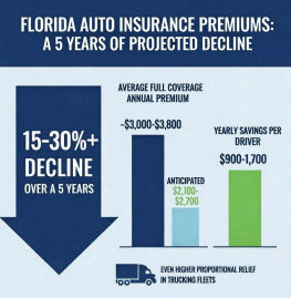
Florida’s elevated rates ($2,668–$3,884 annual full coverage), frequent severe weather events, tourism-driven congestion, and litigation pressures make it an ideal launch market. URGNs™ directly targets the state’s most expensive crash types while aligning with ongoing reforms that reward innovation and cost control.
By enabling insurers to quickly implement data-driven discounts without hardware rollout, URGNs™ can help accelerate rate stabilization and reduction—potentially delivering $900–$1,700 in annual savings per driver over the medium term, while producing enormous societal value through fewer crashes, resolved claims, and safer roads for residents and visitors alike.
In short, URGNs™ is a near-term, ready-to-deploy solution that harnesses existing smartphone ubiquity, infrastructure intelligence, and reform momentum to prevent tragedy, eliminate disputes, and return meaningful value to drivers, fleets, insurers, and society—faster and more effectively than any hardware-dependent approach.
Economic Development Impact in Florida and Job Creation from URGNs™ Deployment
Economic Development in Florida
Statewide deployment of URGNs™ (Ultra-wideband Roadway Geometry Network) across Florida’s roadways—leveraging UWB tags embedded during routine maintenance—would serve as a transformative, low-cost infrastructure upgrade. With Florida’s population approaching approximately 23.4–24.3 million in 2025–2026 and a gross state product (GSP) nearing $1.5–1.7 trillion, URGNs™ aligns with the state’s rapid growth, high traffic volumes, frequent adverse weather (rain/fog), and emphasis on Vision Zero, congestion relief, and mobility innovation.
This terrestrial micropositioning network enables reliable centimeter-level lane guidance in all conditions, overcoming GNSS limitations and accelerating adoption across the 11 market verticals (e.g., robotaxi/ADAS scaling, last-mile delivery, microtransit, VRU safety apps, ports/airports, lane-level tolling, emergency services). It builds on Florida’s existing momentum in connected/autonomous vehicle (CAV) testing (e.g., Orlando as an AV hub with 16,800+ related jobs in Central Florida) and precedents like the THEA CV Pilot in Tampa.
Estimated Economic Development Impact (Annual, Once Mature Deployment Achieved)
Full statewide rollout (phased over 5–10 years, starting in high-density/urban areas like Tampa, Miami, Orlando) could generate substantial net new economic value through productivity gains, reduced externalities (crashes/delays/emissions), investment attraction, tax base expansion, and ecosystem effects.
- Annual Economic Benefit to Florida: $1.5–4 billion (conservative to optimistic midpoint range, scaling from Tampa’s $75–$200 million estimate proportionally to Florida’s ~8–9% share of U.S. fatalities/traffic but adjusted upward for statewide coverage, higher weather relevance, tourism/logistics density, and broader vertical multipliers).
- This includes layered contributions: congestion/fuel savings ($500 million–$1.5 billion+ from optimized routing across fleets/delivery/AVs), redevelopment acceleration (e.g., urban projects, property value/tax growth: $300–$800 million), logistics/ports enhancement (e.g., Port Tampa Bay synergies: $200–$600 million), autonomy hub attraction (tech firms/talent inflow: $300–$800 million), and societal multipliers (lower insurance/healthcare costs, resident/business retention: $200–$600 million).
- Comparable analogies: GPS has delivered ~$1.4–1.7 trillion in cumulative U.S. private-sector benefits (with telematics/location services as major drivers); connected vehicle markets are projected to reach tens to hundreds of billions globally. URGNs™ infrastructure-enabling role could capture a meaningful share in Florida’s mobility sector.
These benefits accrue to the state with zero upfront capital cost via P3 models, routine installation, and subscription revenues (e.g., discounted fleet access, API integrations).
The deployment of URGNs™ (Ultra-wideband Roadway Geometry Network) in Florida, starting with high-impact areas like Tampa, positions the state as a leader in next-generation transportation infrastructure. By providing centimeter-level, all-weather terrestrial micropositioning through UWB tags embedded in routine pavement maintenance, URGNs™ overcomes limitations of traditional GPS, vision-based systems, and connected vehicle technologies in rain, fog, and urban environments—common challenges in Florida’s weather patterns and growing metros.
This infrastructure acts as a foundational enabler for smart mobility, attracting investment, accelerating redevelopment, and enhancing competitiveness. Florida’s rapid population growth, tourism-driven economy, and congestion in cities like Tampa, Miami, and Orlando make URGNs™ a catalyst for inclusive, sustainable growth. Key impacts include:
- Attracting Tech and Mobility Firms: Precise positioning unlocks scalable autonomy, attracting robotaxi operators, ADAS manufacturers, last-mile delivery companies, and shared mobility providers. Tampa’s legacy as host of the THEA Connected Vehicle Pilot (which demonstrated safety benefits like preventing potential crashes and issuing thousands of advisories) provides a proven foundation, positioning the city (and Florida) as a mobility innovation hub. This could spur private investment in tech campuses, testing facilities, and partnerships, boosting GDP through job-creating relocations and expansions.
- Support for Redevelopment and Urban Projects: In Tampa, URGNs™ enhances initiatives like West River, Riverwalk extensions, and Rome Yard by enabling dynamic curb management, microtransit routing, and VRU (vulnerable road user) safety alerts. Improved navigation and reduced congestion increase property values, expand the tax base, and accelerate private development in high-growth corridors.
- Logistics and Ports Enhancement: Tampa’s Port Tampa Bay, a major economic driver, benefits from reliable asset tracking in GNSS-denied environments (e.g., terminals, cargo areas). This improves efficiency, reduces delays, and strengthens Florida’s role in global trade, generating multiplier effects in supply chain jobs and related industries.
- Broader Multipliers: Analogous to how GPS has delivered trillions in U.S. economic benefits through productivity gains (e.g., in telematics, location services, and transportation), URGNs™ creates layered value via reduced externalities (crashes, delays, emissions) and ecosystem effects (lower insurance, faster logistics). Conservative estimates suggest annual economic development benefits to Tampa alone of $75–$200 million (net new value beyond direct city savings of $8–$25 million annually), amplified statewide through urban scaling and tourism/resident retention.
These gains align with Florida’s goals for resilient infrastructure, economic competitiveness, and Vision Zero safety, fostering a high-ROI environment with zero upfront capital cost to public entities via public-private partnership (P3) models.
Job Creation Across 11 Market Verticals Enabled by Terrestrial Micropositioning
URGNs™ precise, GNSS-independent positioning enables 11 high-potential verticals, each driving direct and indirect employment through technology deployment, operations, app development, data services, and supporting industries:
- Level 4/5 Robotaxi OEMs — Scaling unsupervised operations creates manufacturing, software engineering, fleet operations, and maintenance jobs.
- Level 2+/3 ADAS OEMs — Premium features spur R&D, integration, and testing roles in automotive supply chains.
- Last-Mile Delivery — Autonomous/optimized routing boosts warehouse, logistics, and delivery personnel jobs.
- Microtransit & Shared Mobility Operators — On-demand services generate driver, dispatcher, and tech support employment.
- Pedestrian & VRU Safety Apps/Platforms — Smartphone-based alerts drive app development, data analytics, and community outreach positions.
- Consumer Navigation Providers — Enhanced features support software engineers, map data specialists, and premium service teams.
- Government / DoD / Emergency Services — Resilient PNT creates public sector tech integration, training, and operations jobs.
- Advertising & Location Services — Lane-specific targeting fosters digital marketing and data roles.
- Ports and Airports — Asset tracking supports operations, security, and logistics employment.
- VRU Pedestrian/Bike Safety — Cooperative alerts expand safety tech and education jobs.
- Lane-Level Tolling — Infrastructure-light systems create implementation, monitoring, and revenue management positions.
Deployment involves installation during routine maintenance (creating construction, engineering, and contracting jobs), ongoing operations/maintenance, API integrations, and ecosystem growth (e.g., startups, data firms). Similar precision technologies (e.g., GPS) have supported hundreds of thousands of jobs through multipliers in related sectors. In Florida’s context, statewide scaling could generate thousands of direct/indirect jobs over the rollout period, with Tampa’s full deployment amplifying local hiring in tech, mobility, and public services.
Estimated Job Growth
URGNs™ deployment and enabled verticals would create direct jobs (installation, maintenance, tech integration) and indirect/induced jobs (supply chain, app development, operations in verticals, supporting services). Florida’s transportation sector already supports ~743,000 jobs economy-wide, with infrastructure investments historically generating strong multipliers.
- Direct and Indirect Jobs from Deployment and Operations (annual sustained, post-rollout): 5,000–15,000 jobs.
- Installation/maintenance during resurfacing/ADA upgrades: 1,000–3,000 construction/engineering roles (phased over rollout).
- Operations, data services, API/tech support: 2,000–6,000 (similar to CAV/AV ecosystem growth).
- Multiplier effects (e.g., 4–8x leverage in congested metros via productivity/logistics gains): Additional 2,000–6,000 in related sectors.
- Total Jobs Supported Across 11 Verticals (cumulative over 10–20 years, including induced): 20,000–60,000 net new or accelerated jobs statewide.
- High-impact verticals: Robotaxi/ADAS (manufacturing/R&D/testing: thousands in growing AV hubs like Orlando/Central Florida); last-mile delivery/microtransit (logistics/operations: high volume); ports/airports (asset tracking/efficiency: major at Port Tampa Bay); VRU/pedestrian apps (software/data: scalable via smartphones).
- Precedents: AV-related facilities (e.g., HOLON plant in Jacksonville: 700–800 annual jobs); broader CAV/autonomy push supports tens of thousands regionally. URGNs™ amplifies this by enabling weather-resilient scaling, attracting OEMs/fleets, and boosting tourism/resident appeal.
These estimates are conservative to optimistic, grounded in Florida’s transportation economic data (e.g., infrastructure projects yielding billions in impact and thousands of jobs), CAV/AV studies, and analogies to transformative positioning tech like GPS (millions of U.S. jobs supported downstream). Faster pilots (e.g., Tampa/FDOT) and federal grants (SMART/ATTAIN) could accelerate realization, positioning Florida as a national leader in all-weather smart mobility.
URGNs™ delivers not only profound safety/life-saving value but also robust, inclusive economic development and job creation—advancing ethical innovation for Florida’s families, businesses, and communities.
Federal Grant Opportunities
URGNs™ aligns with federal priorities for innovative, safety-focused transportation infrastructure. Proven UWB successes (e.g., NYC MTA subway pilots for non-line-of-sight precision) and parallels to connected vehicle initiatives make it competitive for grants. Examples include:
- Strengthening Mobility and Revolutionizing Transportation (SMART) Grants: Up to $100 million annually (FY 2022–2026) for advanced tech demonstrations improving efficiency/safety; supports connected/autonomous systems and smart community projects.
- Advanced Transportation Technology and Innovation (ATTAIN) Program: Funds deployment of innovative solutions for safety, efficiency, and connectivity, including connected vehicles.
- Other Relevant Programs: Enhancing Mobility Innovation, BUILD (Better Utilizing Investments to Leverage Development) for surface transportation with innovation focus, and potential Build America Bureau support for P3s/innovative finance.
The $22 million secured for NJ TRANSIT’s innovation train project (likely tied to advanced positioning/CBTC integration in rail) exemplifies similar federal support for UWB-enabled transit/rail advancements via FTA or related sources. Florida pilots (e.g., Tampa with FDOT/FHWA alignment) could leverage these for urban/statewide rollouts, accelerating deployment while minimizing public costs.
URGNs™ thus delivers not only life-saving safety but transformative economic development, job growth, and grant-funded momentum for Florida—advancing ethical, Christ-led innovation for thriving communities.
Proven Foundation
UWB has demonstrated reliability in real-world transit deployments:
- NYC MTA subway pilot (with Piper Networks/Thales and Humatics/Siemens): UWB provides inch-level train positioning in 7 and L line tunnels/elevated tracks, integrated with CBTC for safer, more reliable operations—proving UWB works in challenging, non-line-of-sight environments.
- Similar successes in NJ Transit and other rail systems show UWB’s robustness in dense, obstructed settings—directly transferable to roadways.
URGNs™ builds on this proven tech for roadways, with zero ongoing power/maintenance needs and easy integration during routine repaving. It’s an ethical, life-saving innovation that could generate billions in economic benefits (reduced crashes, insurance, delays) while stewarding success toward our Gospel mission. This has enormous potential—pray for the breakthroughs to make it happen quickly!
Other Societal Benefits
Beyond the direct life-saving impact, URGNs™ delivers profound other societal benefits through widespread reductions in crashes, injuries, congestion, and inefficiencies. These stem from its ability to provide reliable, centimeter-level lane positioning in all weather conditions, preventing lane departures, enabling smoother traffic flow, and supporting safer scaling of autonomous and ADAS-equipped vehicles.
Real-world data on U.S. crash costs and congestion impacts, position URGNs™ as a high-impact infrastructure solution. Here’s a detailed breakdown of these benefits, grounded in current statistics:
Injuries Prevented
URGNs™ targets lane departures and weather-related crashes, which contribute heavily to serious injuries. Nationally, motor vehicle crashes result in millions of medically consulted injuries annually — for example, NHTSA data shows ~2.44 million injuries in 2023 (including disabling and non-disabling), with recent estimates around 5.1 million medically consulted injuries in some reports.
Our projection of ~3.8 million fewer serious injuries over the rollout period is possible if URGNs™ is allowed to be deployed and achieve meaningful reductions (e.g., 10–30% in targeted crash types, based on studies of lane departure prevention systems showing 11–60% crash reductions depending on implementation). This would dramatically reduce human suffering, long-term disabilities, and the healthcare burden — freeing up resources for families and society while honoring the value of every life.
Economic Crash Cost Reduction
Motor vehicle crashes impose massive societal costs, including medical care, lost productivity, property damage, legal fees, and more. Recent NHTSA estimates peg the annual economic cost at ~$340 billion (2019 data, adjusted for inflation in later reports), with broader figures reaching $417–$514 billion when including quality-of-life harm and updated injury counts.
We estimate ~$630 billion in avoided crash costs over a 20 year timeframe reflecting cumulative savings from preventing weather/lane-departure crashes (which account for ~15–21% of fatalities and significant injuries/property damage). As URGNs™ rolls out in urban areas and scales nationally, these savings compound — reducing taxpayer burdens (e.g., ~$30 billion in public costs annually) and easing economic strain on households, businesses, and insurers.
Congestion + Fuel Savings
Improved lane accuracy and reduced crashes lead to smoother traffic flow, less stop-and-go, and fewer incidents causing backups. U.S. traffic congestion costs ~$269 billion annually (2024–2025 Texas A&M Urban Mobility Report), with commuters losing ~63 hours/year on average — equivalent to nearly 8 workdays per person, plus wasted fuel and emissions.
We estimate that we can obtain ~$400 billion in congestion + fuel savings, as URGNs™ enables better routing for AVs/robotaxis, delivery fleets, and emergency vehicles, minimizing idling and inefficiencies. Studies on connected/automated tech show fuel economy gains of 5–46% in urban scenarios from smoother driving, with broader system effects (e.g., fewer crashes clearing roads faster) amplifying savings.
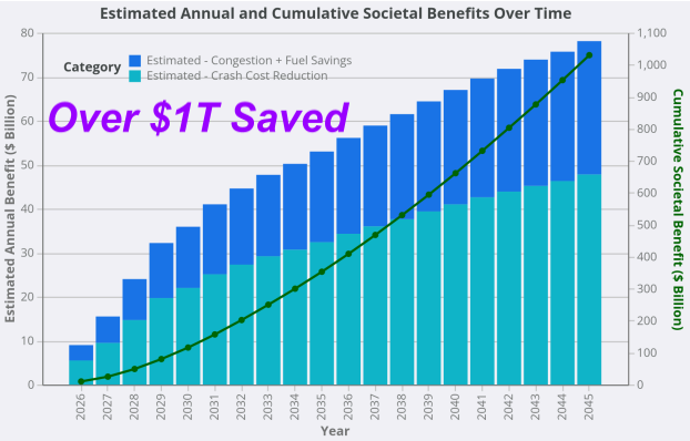
Total Estimated Societal Benefit: ~$1.03 Trillion
Combining these, our $1.03 trillion total over the projection period (e.g., through 2045) represents massive economic and human value — safer mobility, reduced productivity losses, lower healthcare/tax burdens, and environmental gains from less fuel waste/emissions.
To illustrate the growth over time, the chart above shows a conceptual visualization of our chart (based on the described bars and cumulative line):
- Annual benefits ramp up gradually as urban rollouts begin (2026–2030), then accelerate with national adoption.
- Cumulative line (green) shows the exponential societal payoff, reaching over $1 trillion by 2045.
This positions URGNs™ not just as safety tech, but as a transformative investment in America’s infrastructure — delivering ethical, Christ-led innovation that saves lives, stewards resources, and renews communities.
Contact Robert James at Cell: 813-853-4472 Email: rjinnovationinc@gmail.com
Other Articles

Waymo Weather Shutdowns Highlight Need for Smarter Autonomous Vehicle Infrastructure
Article Waymo recently suspended robotaxi operations across Dallas and multiple Texas markets following severe weather conditions and broader autonomous vehicle…

URGNs™ Tampa City Council
FOR IMMEDIATE RELEASEFebruary 3, 2026 URGNs™ Zero‑Cost Precision Mobility Proposal Aligned With Mayor Castor’s Priorities Goes Before Tampa City Council. …
URGNs™ New York
Help Launch URGNs™ in New York, an Inspired Tech to Save Lives URGNs™ (Ultra-wideband Roadway Geometry Network) is designed to…